

Southern Project
Background Information
Since Congress approved a $3 million earmark for the Interstate 73 project, the SCDOT Commission has approved the use of a consultant to complete an initial environmental document.
In June 2003, the SCDOT staff completed a feasibility study that identified a 5,000 square mile study area for I-73 in South Carolina. Within the study area, the SCDOT conducted a planning level review to identify projected traffic volumes and preliminary environmental impacts associated with new location alternatives, as well as the upgrade of existing routes US 501 and SC 9 to interstate standards. The SCDOT study is preliminary, and was intended to initiate further environmental and engineering analyses. The review assessed environmental and social constraints, estimated traffic demand, alignment and design criteria, and preliminary costs of the project.
This study indicated that potential I-73 corridors for the entire project would be approximately 90 miles in length with projected traffic volumes of approximately 60,000 vehicles per day. Preliminary cost estimates range between $1 and $2 billion.
In mid-2004, SCDOT selected a consultant to perform the studies necessary to produce an Environmental Impact Statement (EIS). During the summer of 2004, the project team prepared two Notices of Intent (one for a project from I-95 to the South Carolina/North Carolina State line, and another for a project from I-95 to the Myrtle Beach area) which were published in August. In August and September of that year, the consultant conducted project scoping meetings with the resource agencies and the public to receive input about issues and concerns regarding the construction of the project between I-95 and the Myrtle Beach area.
In late 2004 the Project Team, working with the various resource agencies and with regard to comments received from the public during the scoping meetings, began to develop potential alternative corridors for the project between I-95 and the Myrtle Beach area to present to the public. These potential corridors were developed to minimize impacts to environmental considerations such as wetlands, streams and other watercourses, threatened and endangered species sites, archaeological sites, and other valuable resources.
Four Public Information Meetings were held in March and May of 2005. The Potential Alternative Corridors shown at the meetings (and that are shown on this Website) were developed based on minimizing impacts to the environment. The Project Team is currently evaluating the community impacts of the various corridors. We will be attempting to strike an appropriate balance between environmental considerations and impacts to communities. No decisions have yet been made regarding any of the corridors.
Using the comments we received from these Public Information Meetings, comments we received on the Project Website and Telephone Hotline, and other factors that are pertinent to the Project Study Area, the Project Team developed a recommended Preferred Alternative that was presented to the public on May 30, 2006. A series of three Public Hearings, one in each county, was conducted in mid-June 2006. After the Public Hearings were completed, members of the Project Team performed field investigations to document conditions along the Preferred Alternative. These field investigations began in July and continued through the fall.
The Project Team continued with the public involvement process, in coordination with all Counties located within the project study area. These activities include public information meetings, briefings and presentations, maintaining the project website and telephone hotline, and other activities that are intended to help keep the public aware of the status of the project.
The SCDOT and the FHWA approved the Final Environmental Impact Statement document on November 29, 2007.
On February 8, 2008, S.C. Secretary of Transportation H.B. “Buck” Limehouse and U.S. Department of Transportation Deputy Secretary Thomas Barrett signed the Record of Decision (ROD) for I-73 South during a brief ceremony in Myrtle Beach. The ROD represents the final approval of the Final Environmental Impact Statement (FEIS) and completes the environmental review process for the I-73 South Project. The ROD, which is approved by the Federal Highway Administration (FHWA), locks in the Selected Alternative. The FHWA approval of the ROD also permits the South Carolina Department of Transportation (SCDOT) to begin expending currently available federal funding in the acquisition of right of way for the project.
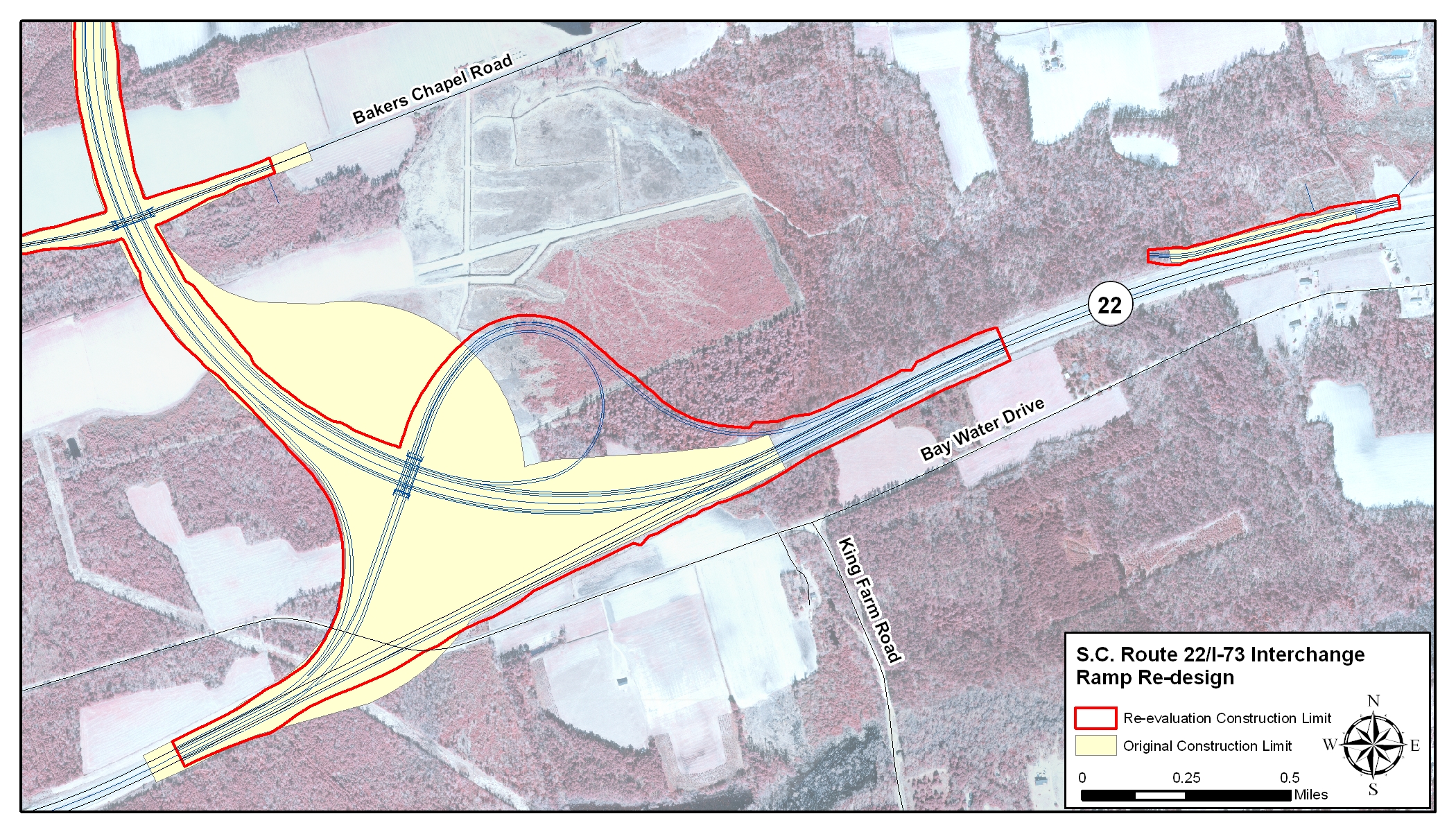
During April and May of 2009, the SCDOT and FHWA conducted a Value Engineering Study to find design changes and other measures that would result in cost savings for the I-73 South project. The study resulted in a total construction cost savings of an estimated $45.8 million dollars. One major cost savings was the change in the design of the S.C. Route 22/I-73 interchange. The interchange was changed from a three-level structure to a two-level one, which eliminated bridges and reduced the construction costs by $31.1 million. Figure: SC22 Interchange.
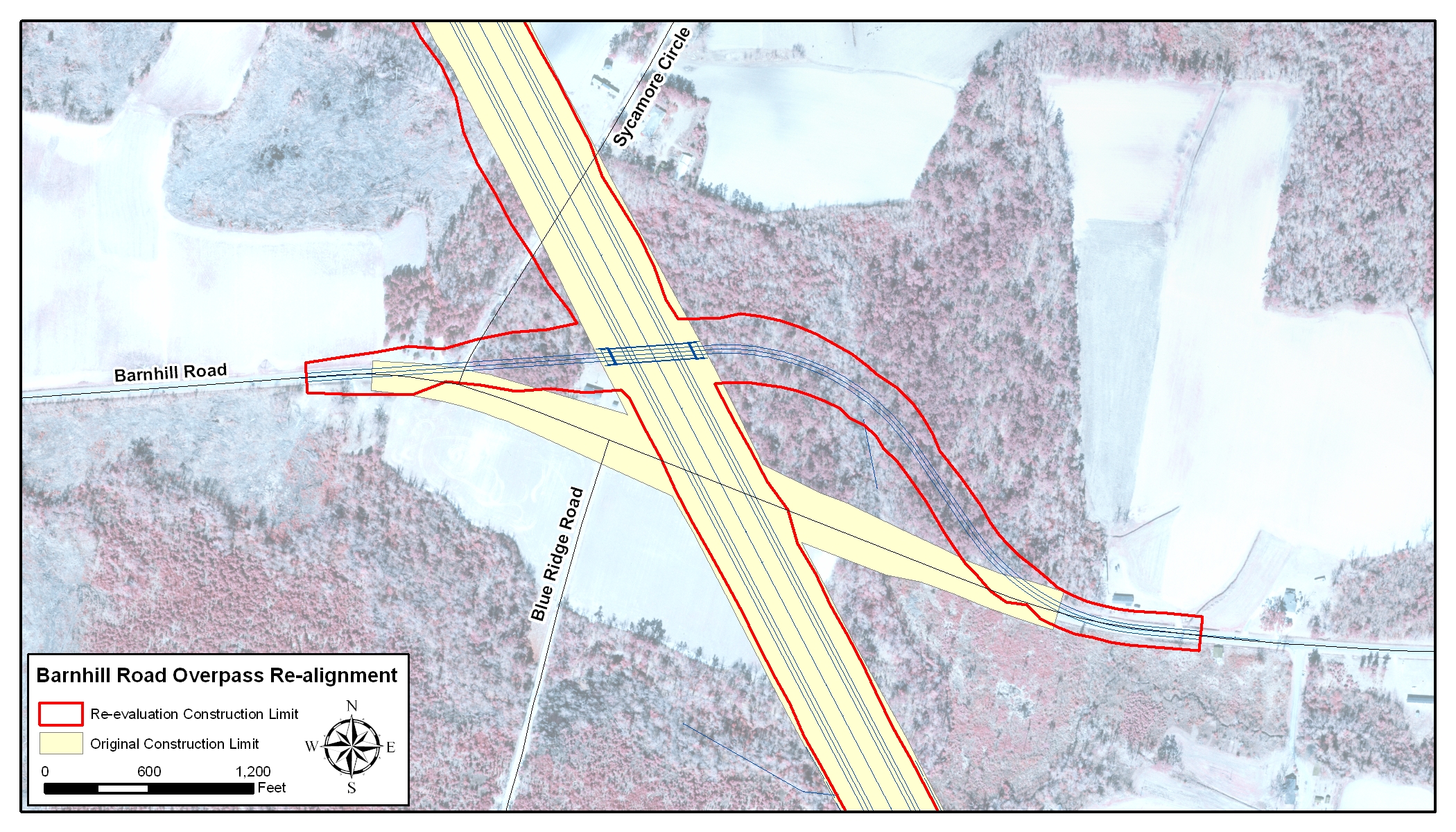
Other changes that helped reduce costs were the elimination of rest areas, which saved $20 million in construction costs, and will also save SCDOT additional money in long-term maintenance costs. The Barnhill Road (S-26-309) overpass was also re-aligned so that the bridge was shorter, which further reduced construction costs by $1.1 million. Figure: Barnhill Road Overpass.
Value Engineering Study: Part 1 (5.64mb pdf), Part 2 (3.28mb pdf).
In May 2009, the SCDOT Commission voted to focus efforts on I-73 to identify sufficient funding for the segment of I-73 between I-95 and US 501 in Dillon County. Right of way acquisitions on this section began during Summer 2010 and should be completed in early 2012. The intent is to construct a portion of I-73 in this area.
The (right-of-way) ROW plans for the I-73 South project between I-95 and S.C. Route 22 were completed in September of 2009. This allows SCDOT to more precisely identify the properties and portions of properties that will need to be obtained to build I-73, as funding becomes available. Property strip maps, showing the right-of-way to be obtained, are available on this website. Right of Way Plans
Several parcels that were to be taken entirely have already been purchased for the right of way for I-73 South. SCDOT is focusing on acquiring rights of way between S-17-38 (Centerville Road) on the north side of I-95, to the Dillon/Marion county line, south of I-95. Right of way acquisitions for this area began during the Summer of 2010 and should be completed in early 2012. This section is planned to be the first phase constructed. Figure: I-73 South between I-95 and U.S. 501.
On May 7, 2010, the FHWA approved the written Re-evaluation of the I-73 South Final Environmental Impact Statement (FEIS), which was prepared to address the impacts associated with the changes to the design that resulted from the Value Engineering Study and the preparation of the final ROW plans. Seven design changes were evaluated in the Re-evaluation, which included the following:
- I-95/I-73 Interchange Ramp Widening – Widening of the interchange ramps from one 16-foot lane to two 12-foot lanes. Figure: I-73, I-95 Interchange.
- S.C. Route 22/I-73 Interchange Ramp Re-design – Elimination of bridges by making the ramp a two-level design instead of three-level design. Figure: SC22 Interchange;
- Barnhill Road (S-26-309) Overpass Re-alignment – Straightening of Barnhill Road overpass and shortening overpass bridge. Figure: Barnhill Road Overpass.
- Elimination of Rest Areas – Elimination of rest areas for both the north and southbound travel lanes.
- Derrick Road Re-alignment – re-alignment of Derrick Road farther west to meet design criteria. Figure: Derrick Road_WaterMill Road Realignment.
- Good Luck Road (S-26-569) Re-alignment – re-alignment of Good Luck Road to straighten the roadway in vicinity of the overpass. Figure: Good Luck Road Overpass.
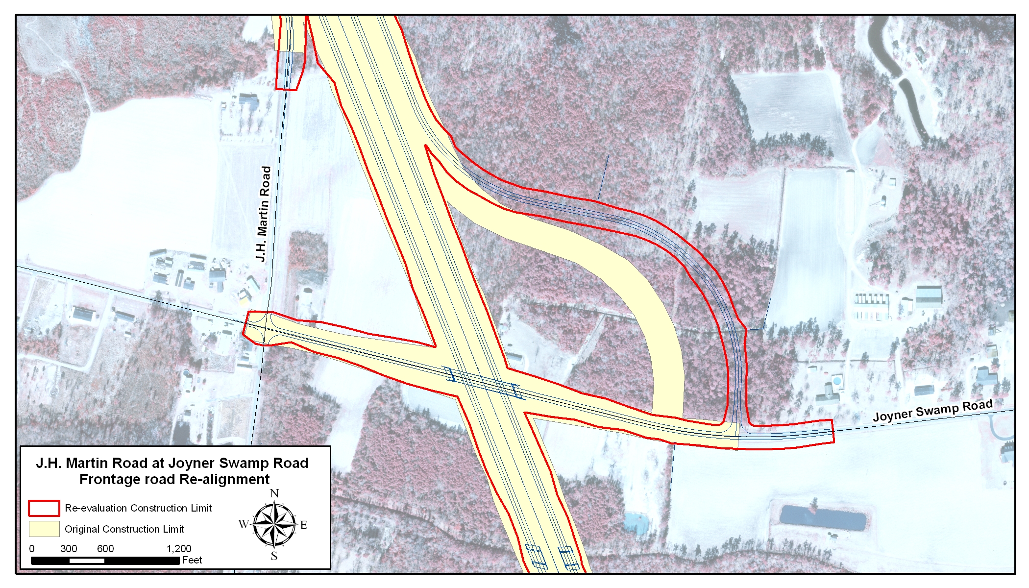
- J.H. Martin Road at Joiner Swamp Road (S-26-45) Frontage Road Re-alignment – the frontage road for J.H. Martin Road was moved to avoid the relocation of a new house that had been constructed since the original right of way plans. Figure: Joyner Swamp Frontage Road.
The proposed design changes would decrease the overall wetland impacts by 0.26 acre and avoid one relocation, but would increase the impacts to protected farmland soils by 9.19 acres. These impacts are shown in the table below. [view larger]
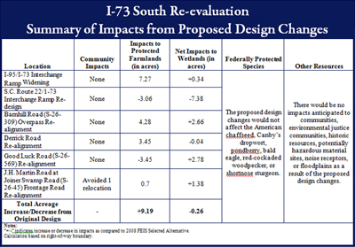
No other impacts to human or natural resources in the project study area would be anticipated.
I-73 South Re-evaluation Section 1 (2.04mb pdf), Section 2 (5.64mb pdf), Section 3 (3.28mb pdf).
Current Status
Section 404 wetland permit application for I-73 has been submitted
A Clean Water Act Section 401/404 permit application for impacts from the I-73 project on wetlands, streams, and other jurisdictional waters, was submitted to the U.S. Army Corps of Engineers (USACE) and the South Carolina Department of Health and Environmental Control (SCDHEC) on January 4, 2011. SCDOT is working with the USACE and SCDHEC to process this major permit application, which includes potential construction impacts and a plan for providing mitigation for the unavoidable wetland and stream impacts associated with I-73. The permit application was issued for a 30-day public review period on January 26, 2011. SCDOT has conducted several coordination meetings with the USACE and SCDHEC to address public and agency comments that were received as a result of the public notice. Agency review of the permit application is ongoing, as is SCDOT coordination with these agencies.
Final design has begun on I-73 South
The final design for the section of I-73 from I-95 to US Route 501 began in July 2011. This design includes 10 bridges, as well as drainage, geotechnical, maintenance of traffic and traffic control, signage, pavement marking, erosion control and utility plans. Other services included in the contract are final surveys, utility coordination, railroad coordination and construction support. Anticipated completion of the final construction plans is in mid April 2012. Depending on available funding and the receipt of the Clean Water Act Section 401/404 permit, construction could begin by the end of 2012. This will be the first section of I-73 to be designed and constructed in South Carolina, and will ultimately provide a vital link between I-95 and the Grand Strand/Myrtle Beach area.


Property of the South Carolina Department of Transportation. Copyright © 2007 www.scdot.org.
Please refer to the SCDOT's Internet Disclaimer for proper usage of this site.