

Interstate 73 was identified as a high priority route from Michigan to South Carolina in the Intermodal Surface Transportation Equity Act (ISTEA) that the US Congress passed in 1991. This Website provides information regarding the portion of Interstate 73 for which environmental studies have recently been completed by the South Carolina Department of Transportation.
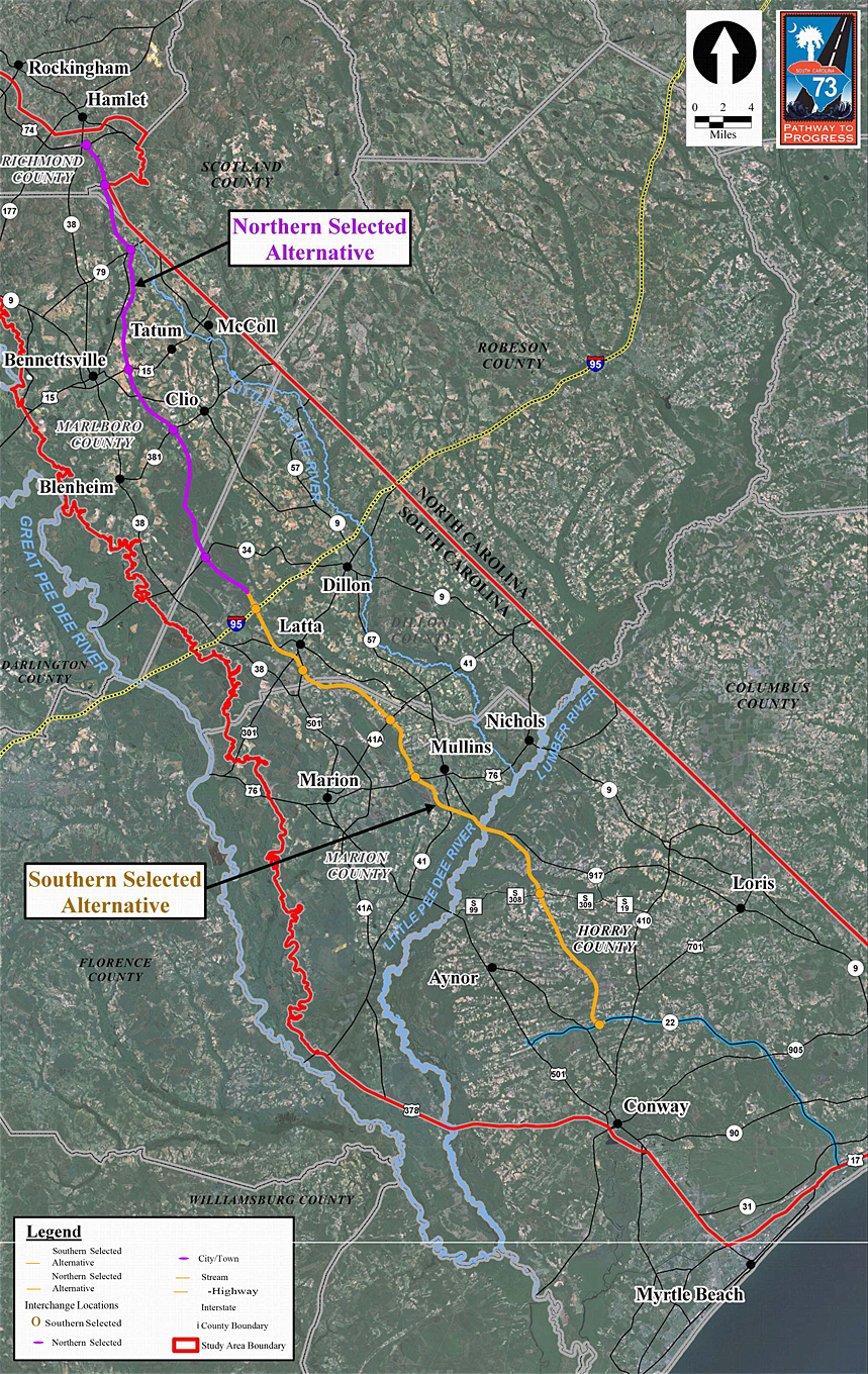
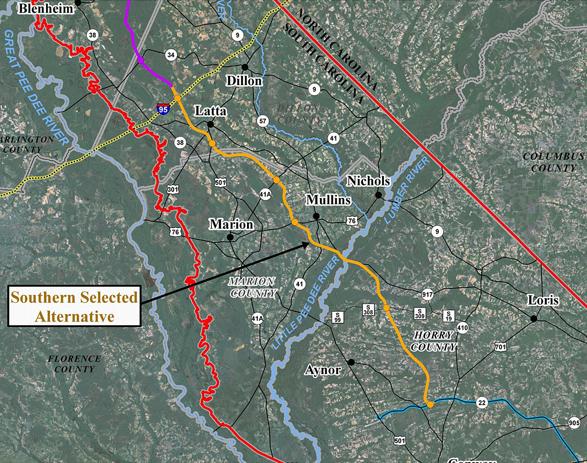
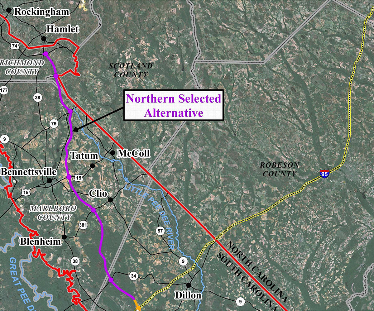
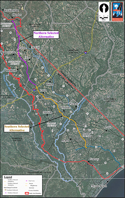
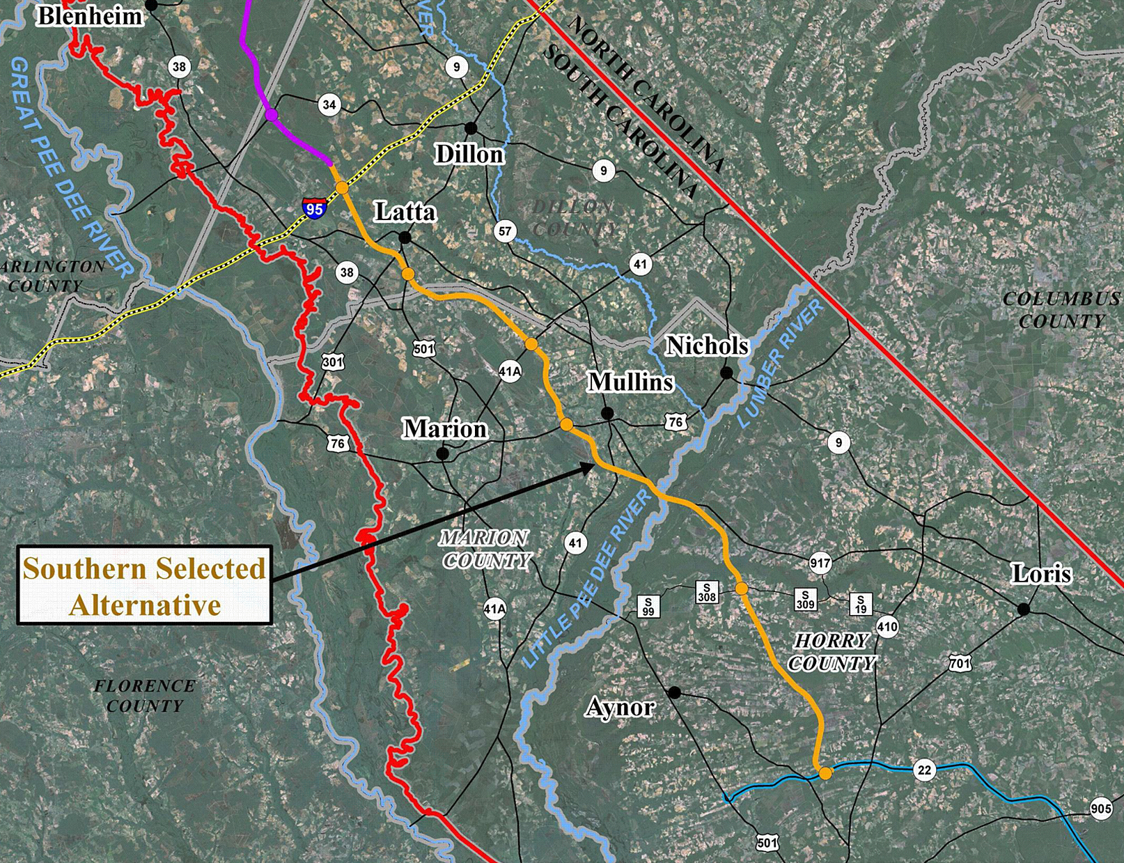
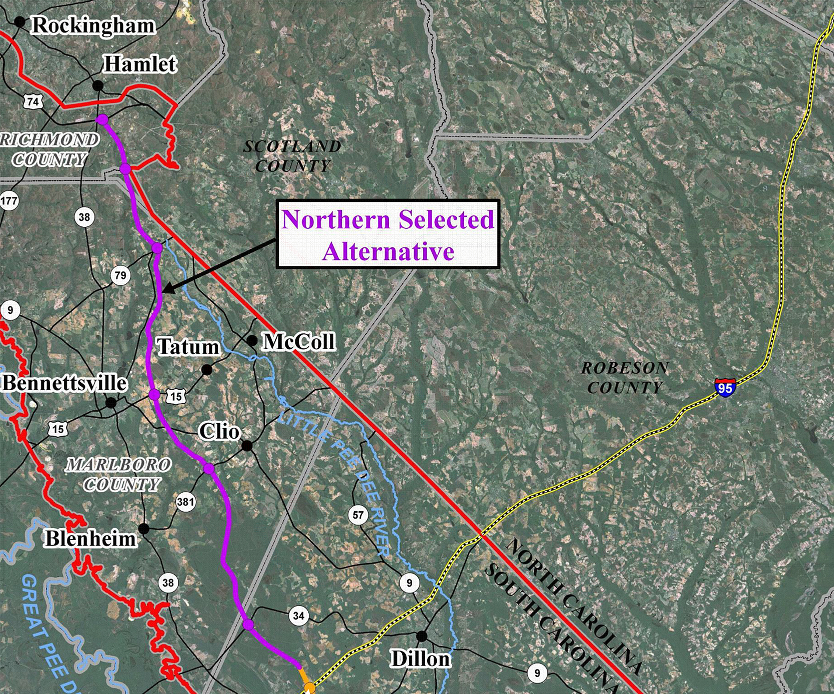
The study area for I-73 in South Carolina followed the Great Pee Dee River to US 378 west of Conway, traveled along US 378 to US 501 and followed US 501 to the coast. It then proceeded up the coast to the North Carolina state line and then ran along the state line to the northwest corner of Scotland County, North Carolina. It extended along the Scotland and Rockingham County line to the northern side of I-74 in Rockingham County, then west along US 1 to the floodplain of the Great Pee Dee River. This study area was divided into two projects. The Northern Project ties to Interstate 73/74 in the Rockingham/Hamlet, North Carolina region and runs south across the South Carolina/North Carolina state line through Marlboro and Dillon Counties to a connection at Interstate 95. The Southern Project continues from Interstate 95 and run to State Route 22 (Conway Bypass, or Veteran's Highway) in the Myrtle Beach/Conway area. The Northern and Southern Projects are shown in the maps to the right.
In May 2009 the SCDOT Commission voted to focus efforts on I-73 to identify sufficient funding for the segment of I-73 between I-95 and US 501 in Dillon County. Right of way acquisitions on this section will begin by late summer 2010. The intent is to construct a portion of I-73 in this area. Figure: I-73 South between I-95 and U.S. 501.
SCDOT and FHWA conducted a Value Engineering Study to find design changes and other measures that would result in cost savings for the I-73 South project. The study resulted in a total construction cost savings of an estimated $45.8 million dollars. One major cost savings was the change in the design of the S.C. Route 22/I-73 interchange. The interchange was changed from a three-level structure to a two-level one, which eliminated bridges and reduced the construction costs by $31.1 million. Figure: SC22 Interchange. Other changes that helped reduce costs were the elimination of rest areas, which saved $20 million in construction costs, and will also save SCDOT additional money in long-term maintenance costs. The Barnhill Road (S-26-309) overpass was also re-aligned so that the bridge was shorter, which further reduced construction costs by $1.1 million. Figure: Barnhill Road Overpass.
Value Engineering Study: Part 1 (5.64mb pdf), Part 2 (3.28mb pdf).
The (right-of-way) ROW plans for the I-73 South project between I-95 and S.C. Route 22 were completed in September of 2009. These plans incorporate design features, such as detailed drainage design. This allows SCDOT to more precisely identify the properties and portions of properties that will need to be obtained to build I-73, as funding becomes available. Property strip maps, showing the right-of-way to be obtained, are available on this website.
Several parcels that were to be taken entirely have already been purchased for the right of way for I-73 South. SCDOT is focusing on acquiring rights of waybetween S-17-38 (Centerville Road) on the north side of I-95, to the Dillon/Marion county line, south of I-95. Right of way acquisitions for this area will begin in the Fall of 2009. This section is planned to be the first phase of construction. Figure: I-73 South between I-95 and U.S. 501.
A written Re-evaluation of the I-73 South Final Environmental Impact Statement (FEIS) was prepared to address the impacts associated with the changes to the design that resulted from the Value Engineering Study and the preparation of the final ROW plans. Seven design changes were evaluated in the Re-evaluation, which included the following:
The proposed design changes would decrease the overall wetland impacts by 0.26 acre and avoid one relocation, but would increase the impacts to protected farmland soils by 9.19 acres. These impacts are shown in the table below. [view larger]
No other impacts would be anticipated to other human or natural resources in the project study area. The I-73 South Re-evaluation was approved by the FHWA on May 7, 2010.
I-73 South Re-evaluation Section 1 (2.04mb pdf), Section 2 (5.64mb pdf), Section 3 (3.28mb pdf).
A U.S. Army Corps of Engineers (USACE) permit for impacts to wetlands, streams, and other jurisdictional waters is being prepared for the I-73 project. After the final right of way plans were received and the design changes were made, the amount of wetland impacts were reduced from the amounts shown in the Environmental Impact Statements for both I-73 North and I-73 South. The permit application is in its final stages of preparation. SCDOT is working with the USACE to develop this major permit application. This permit will include potential construction impacts and a plan for providing mitigation for the unavoidable wetland and stream impacts associated with I-73.
Additional information regarding both the Northern Project and the Southern Project is available on their respective Pages.
Northern Project (54kb PDF file) First published on August 9, 2004. Revised Notice of Intent published on July 22, 2005
Southern Project (58kb PDF file) - Published on August 9, 2004.
I-73 South Record of Decision (314kb PDF file) - Signed on February 8, 2008
I-73 North Record of Decision (23.17mb PDF file) - Signed on October 22,, 2008
The Project Team periodically makes Project Newsletters available to the public through this Website. These newsletters are intended to inform the public about the progress of the environmental studies, as well as to educate the public about specific aspects of the project.
Issue No. 1(477kb PDF file)
Issue No. 2 (2.24mb PDF file)
Issue No. 3 (3.97mb PDF file)
“Highways and You” (487kb PDF file)
Property of the South Carolina Department of Transportation. Copyright © 2007 www.scdot.org.
Please refer to the SCDOT's Internet Disclaimer for proper usage of this site.