
Northern Corridor Selected Alternative
The Selected Alternative, as approved in the Record of Decision, is shown in the map below. This map uses the County road maps in the Study Area. You may access detailed views of this map by clicking on the portion of this map in your area of interest.
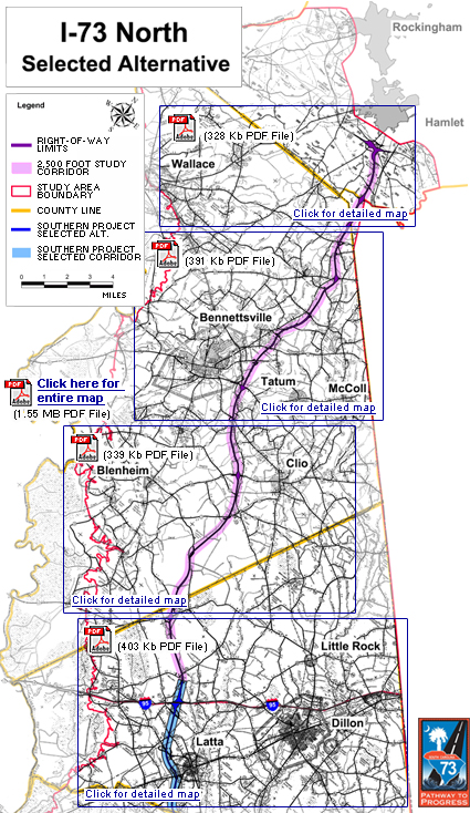
Entire Corridor Map LARGE (5.89mb PDF file)
Entire Corridor Map (1.55kb PDF file)
Wallace Map Detail (328kb PDF file)
Bennetsville Map Detail (391kb PDF file)
Blenheim/Clio Map Detail (339kb PDF file)
Latta/Dillon Map Detail (403kb PDF file)
Northern Project Study Area
The Northern Project study area follows the Great Pee Dee River to Interstate 95, travels along Interstate 95 up to the South Carolina/North Carolina state line, and runs along the state line back to the Rockingham/Hamlet, North Carolina area. The study includes a part of North Carolina in this Rockingham/Hamlet area from Interstate 74 south to the state line. This study area is shown in the map below:
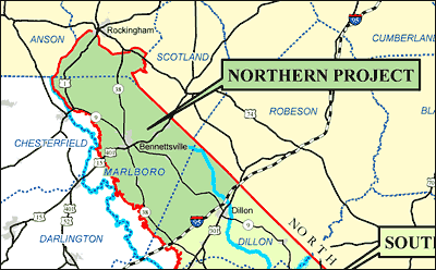 Download the map showing the location of the Northern Project (983kb PDF File)

Property of the South Carolina Department of Transportation. Copyright © 2007 www.scdot.org.
Please refer to the SCDOT's Internet Disclaimer for proper usage of this site.